
Published 2025-08-05
Keywords
- DANA,
- cut-off low,
- GIS,
- remote sensing,
- International Charter: Space and Major Disasters
- Copernicus Emergency Management Service,
- natural hazards,
- disaster management,
- territorial planning ...More
How to Cite
Copyright (c) 2025 Iván Franch-Pardo, Pau A. Fuster Puig, Artemia Cerdà

This work is licensed under a Creative Commons Attribution 4.0 International License.
Accepted 2025-08-04
Published 2025-08-05
Abstract
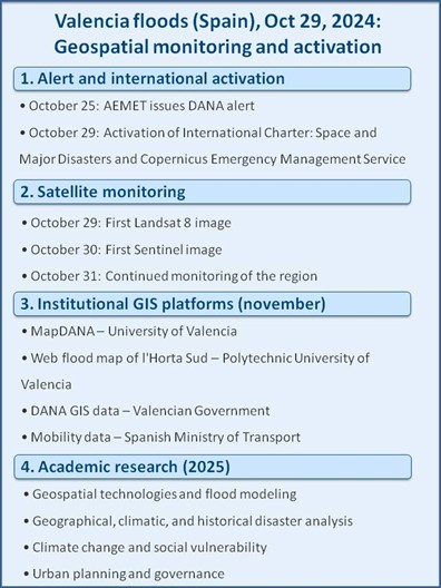
On October 29, 2024, a cut-off low (DANA) caused the most catastrophic flooding in recent history in Spain and the Mediterranean region, in Valencia, resulting in 228 deaths, more than €13 billion in damages, and the disabling of more than 140,000 vehicles. In the days following the disaster, a lack of information and a limited institutional response created a climate of uncertainty. In this context, satellite imagery became the only reliable source of information. This study adopts a systematic review methodology to reconstruct and critically analyze how geospatial technologies were used for forecasting, documenting, and managing the disaster. It draws on a compilation of meteorological datasets, satellite imagery (e.g., Sentinel, Landsat), GIS outputs, institutional maps, and academic research. The research identifies four chronological phases: First, meteorological data were employed to sound the alarm; second, satellite imagery products were used when the disaster already occurred; third, development of web platforms with geographic information and other institutional servers for data download; and four, new lines of research with the inputs generated in the previous points. The intervention of international coordination platforms—the Copernicus EMS rapid mapping service and the International Charter: Space and Major Disasters—allowed, in record time, the processing of the first satellite images and the expedited mapping of flooded areas. The findings demonstrate that spatial analysis tools are one of the most important inputs when dealing with a natural disaster, especially in the first hours and days following the event. However, prior territorial planning and the prompt intervention of decision-makers when such an event occurs are the most decisive factors in minimizing damage. The study also contrasts climate change-based explanations with historical-geographic interpretations of the disaster, underscoring the need for a comprehensive, geographically grounded approach to future risk management.
Highlights:
- Geospatial analysis and geography play a crucial role at the onset of global emergencies.
- At the onset of the event, international remote sensing platforms were the only valid source.
- Climate change and historical geography are the two approaches that explain these floods.
- After DANA, new flood models, hydrometeorological explanations, planning proposals and social vulnerability approaches were developed.
Downloads


References
- Abdalla, R., & Esmail, M. (2019). WebGIS for disaster management and emergency response. Springer International Publishing. https://doi.org/10.1007/978-3-030-03828-1
- AEMET (2024a). Estudio sobre la situación de lluvias intensas, localmente torrenciales y persistentes, en la Península Ibérica y Baleares entre los días 28 de octubre y 4 de noviembre de 2024. Agencia Estatal de Meteorología. Gobierno de España. https://www.aemet.es/es/conocermas/recursos_en_linea/publicaciones_y_estudios/estudios/detalles/episodio_dana_oct_nov24
- AEMET (2024b). Informe sobre el episodio meteorológico de precipitaciones torrenciales y persistentes ocasionadas por una DANA el día 29 de octubre de 2024. Agencia Estatal de Meteorología. Gobierno de España. https://www.aemet.es/documentos/es/conocermas/recursos_en_linea/publicaciones_y_estudios/estudios/informe_episodio_dana_29_oct_2024_.pdf
- Alcaras, E. (2025). Flood Mud Index (FMI): A Rapid and Effective Tool for Mapping Muddy Areas After Floods—The Valencia Case. Remote Sens-ing, 17(5), 770. https://doi.org/10.3390/rs17050770
- Ajmar, A., Boccardo, P., Broglia, M., Kucera, J., Giulio‐Tonolo, F., & Wania, A. (2017). Response to flood events: The role of satellite‐based emer-gency mapping and the experience of the Copernicus emergency management service. Flood damage survey and assessment: New insights from research and practice, 211-228. https://doi.org/10.1002/9781119217930.ch14
- Amiri, A., Gumiere, S. J., Gharabaghi, B., & Bonakdari, H. (2025). From warm seas to flooded streets: The impact of sea surface temperature on cutoff low and extreme rainfall in Valencia, Spain. Journal of Flood Risk Management, 18(1). https://doi.org/10.1111/jfr3.13055
- Arthur, R., Boulton, C. A., Shotton, H., & Williams, H. T. (2018). Social sensing of floods in the UK. PloS one, 13(1), e0189327. https://doi.org/10.1371/journal.pone.0189327
- Avila-Aceves, E., Plata-Rocha, W., Monjardin-Armenta, S. A., & Rangel-Peraza, J. G. (2023). Geospatial modelling of floods: a literature review. Stochastic environmental research and risk assessment, 37(11), 4109-4128. https://doi.org/10.1007/s00477-023-02505-1
- Ballester, J., Quijal-Zamorano, M., Méndez Turrubiates, R. F., Pegenaute, F., Herrmann, F. R., Robine, J. M., ... & Achebak, H. (2023). Heat-related mortality in Europe during the summer of 2022. Nature medicine, 29(7), 1857-1866. https://doi.org/10.1038/s41591-023-02419-z
- Bessis, J. L., Bequignon, J., & Mahmood, A. (2004). The international charter “space and major disasters” initiative. Acta Astronautica, 54(3), 183-190. https://doi.org/10.1016/S0094-5765(02)00297-7
- Braik, A. M., & Koliou, M. (2024). Automated building damage assessment and large‐scale mapping by integrating satellite imagery, GIS, and deep learning. Computer‐Aided Civil and Infrastructure Engineering, 39(15), 2389-2404. https://doi.org/10.1111/mice.13197
- Cabello, M., Galar, M., Sesma, R., Aranda, C., & Albizua, L. (2020). Super-resolution and segmentation: Scaling up the Sentinels in Europe. 4th Workshop - Scaling up the Sentinels in Europe, EuroSDR. https://tracasa.es/innovative-stories/senx4-at-the-cutting-edge-of-superresolution-technology/
- Calvo-Sancho, C., Díaz-Fernández, J., González-Alemán, J. J., Azorín-Molina, C., Halifa-Marín, A., Montoro-Mendoza, A., ... & Martín, M. L. (2025). Anthropogenic Climate Change Attribution to a Record-breaking Precipitation Event in October 2024 in Valencia, Spain (No. EGU25-15941). Copernicus Meetings. https://meetingorganizer.copernicus.org/EGU25/EGU25-15941.html
- Castro-Melgar, I., Falaras, T., Basiou, E., & Parcharidis, I. (2025). Assessment of the October 2024 Cut-Off Low Event Floods Impact in Valencia (Spain) with Satellite and Geospatial Data. Remote Sensing, 17(13), 2145. https://doi.org/10.3390/rs17132145
- CEMS (2024a). EMSR773 - AOI01: Flood in Spain - Valencia Province, Delineation Map 01, Product version 1. Map produced by SERTIT, released by e-GEOS on 02/11/2024. Copernicus Emergency Management Service . European Union. https://rapidmapping.emergency.copernicus.eu/EMSR773/download
- CEMS (2024b). Flood in Valencia Region, Spain. EMSR773 - Situational reporting. Copernicus Emergency Management Service. European Union. https://storymaps.arcgis.com/stories/9ff57e9320dd440eb2ce8d20e62c92cd
- CEMS (2024c). EMSR773 - AOI04: Flood in Spain - Algemesí, Delineation Map 01, Product version 1. Map produced by IABG, released by e-GEOS on 31/10/2024. Copernicus Emergency Management Service. European Union. https://rapidmapping.emergency.copernicus.eu/EMSR773
- CGAT-UPV (2025). Mapa d'inundació carrer a carrer de l'Horta Sud 2024. Grup de Cartografia GeoAmbiental i Teledetecció. Universitat Politècnica de València. https://dana2024.upvusig.car.upv.es/
- Cortiços, N. D., & Duarte, C. C. (2025). Climate Resilience and Adaptive Strategies for Flood Mitigation: The Valencia Paradigm. Sustainability, 17(11), 4980. https://doi.org/10.3390/su17114980
- Delgado, A. (2024). Tres de cada diez viviendas afectadas por la DANA en Valencia se construyeron en zona inundable durante la burbuja. Data-dista. 3 de noviembre. https://www.datadista.com/playa-burbuja/tres-de-cada-diez-viviendas-afectadas-por-la-dana-en-valencia-se-construyeron-durante-la-burbuja-inmobiliaria-2/#:~:text=h%C3%A1bitos%20de%20navegaci%C3%B3n.-,Tres%20de%20cada%20diez%20viviendas%20afectadas%20por%20la%20DANA%20en,zona%20inundable%20durante%20la%20burbujaandtext=M%C3%A1s%20de%2075.000%20viviendas%20afectadas,el%20Patricova%20aprobado%20en%202003
- Durlević, U. (2021). Assessment of torrential flood and landslide susceptibility of terrain: Case study-Mlava River Basin (Serbia). Гласник Српског географског друштва, 101(1), 49-75.
- ESA (2024). Sentinel-2 satellite image of Valencia, Spain, acquired October 31, 2024. Copernicus Open Acces. European Space Agency. https://www.esa.int/ESA_Multimedia/Images/2024/10/Valencia_flood_disaster
- Faranda, D., Álvarez-Castro, M. C., Ginesta, M., Coppola, E., & Pons, F. M. E. (2024). Heavy precipitations in October 2024 South-Eastern Spain DANA mostly strengthened by human-driven climate change. ClimaMeter. Institut Pierre Simon Laplace. CNRS. https://doi.org/10.5281/zenodo.14052042
- Fekete, A. (2009). Validation of a social vulnerability index in context to river-floods in Germany. Natural Hazards and Earth System Sciences, 9(2), 393-403. https://doi.org/10.5194/nhess-9-393-2009
- Fekete, A., Estrany, J., & Ramírez, M. Á. A. (2025). Cascading impact chains and recovery challenges of the 2024 Valencia catastrophic floods. Discover Sustainability, 6(1), 1-31. https://doi.org/10.1007/s43621-025-01483-4
- Fernandes, M., Heesom, D., Fullen, M., & Antunes, F. (2020). Flood dynamics: a geoecological approach using historical cartography and GISci-ence in the city of Petrópolis (Brazil). European Journal of Geography, 11(1). https://doi.org/10.48088/ejg.m.fer.11.1.73.92
- Franch‐Pardo, I., Desjardins, M. R., Barea‐Navarro, I., & Cerdà, A. (2021). A review of GIS methodologies to analyze the dynamics of COVID‐19 in the second half of 2020. Transactions in GIS, 25(5), 2191-2239. https://doi.org/10.1111/tgis.12792
- Galvez-Hernandez, P., Dai, Y., & Muntaner, C. (2025). The DANA disaster: unraveling the political and economic determinants for Valencia’s floods devastation. International Journal for Equity in Health, 24(1), 64. https://doi.org/10.1186/s12939-025-02435-0
- Gill, J. C., & Malamud, B. D. (2014). Reviewing and visualizing the interactions of natural hazards. Reviews of geophysics, 52(4), 680-722. https://doi.org/10.1002/2013RG000445
- González Jiménez, A., & Calvo Guinea, C. (2020). Transport Network Geographic Reference Information as support in linear referencing projects. Revista internacional Mapping, 29(199), 30-38. ISSN: 1131-9100
- Grau-Bove, J., Higham, R., Orr, S., & Kumar, P. (2024). Short note on the mapping of heritage sites impacted by the 2024 floods in Valencia, Spain. ArXiv preprint. arXiv:2411.08717.
- Green, A. C., Fowler, H. J., Blenkinsop, S., & Davies, P. A. (2025). Precipitation extremes in 2024. Nature Reviews Earth & Environment, 6(4), 243-245. https://doi.org/10.1038/s43017-025-00666-x
- Harrison, S., Macklin, M. G., Toonen, W. H., Benito, G., & Cohen, K. M. (2025). Robust climate attribution of modern floods needs palaeoflood science. Climatic Change, 178(4), 71. https://doi.org/10.1007/s10584-025-03904-9
- He, K., Yang, Q., Shen, X., Dimitriou, E., Mentzafou, A., Papadaki, C., ... & Anagnostou, E. N. (2024). Brief communication: Storm Daniel flood impact in Greece in 2023: mapping crop and livestock exposure from synthetic-aperture radar (SAR). Natural Hazards and Earth System Sci-ences, 24(7), 2375-2382. https://doi.org/10.5194/nhess-24-2375-2024
- ICSMD (2024). Flood in Spain. International Charter Space and Major Disasters. https://disasterscharter.org/es/activations/flood-in-spain-activation-924-
- ICV (2024). Visor cartográfico DANA 2024. Institut Cartogràfic Valencià. Generalitat Valenciana. https://visor.gva.es/visor/index.html?idioma=es
- IVIE (2024). La dana deja en Valencia cifras que duelen, sobre las que reflexionar. Instituto Valenciano de Investigaciones Económicas. 15 de noviembre. https://www.ivie.es/es_ES/la-dana-deja-en-valencia-cifras-que-duelen-sobre-las-que-reflexionar/
- Klein, R. J., Nicholls, R. J., & Thomalla, F. (2003). Resilience to natural hazards: How useful is this concept?. Global environmental change part B: environmental hazards, 5(1), 35-45. https://doi.org/10.1016/j.hazards.2004.02.001
- Li, W., Haunert, J. H., Knechtel, J., Zhu, J., Zhu, Q., & Dehbi, Y. (2023). Social media insights on public perception and sentiment during and after disasters: The European floods in 2021 as a case study. Transactions in GIS, 27(6), 1766-1793. https://doi.org/10.1111/tgis.13097
- Martinis, S., Twele, A., Plank, S., Zwenzner, H., Danzeglocke, J., Strunz, G., ... & Dech, S. (2017). The international charter ‘space and major disas-ters’: DLR’s contributions to emergency response worldwide. PFG–Journal of Photogrammetry, Remote Sensing and Geoinformation Sci-ence, 85(5), 317-325. https://doi.org/10.1007/s41064-017-0032-1
- Merz, B., Blöschl, G., Vorogushyn, S., Dottori, F., Aerts, J. C., Bates, P., ... & Macdonald, E. (2021). Causes, impacts and patterns of disastrous river floods. Nature Reviews Earth & Environment, 2(9), 592-609. https://doi.org/10.1038/s43017-021-00195-3
- Meyer, V., Becker, N., Markantonis, V., Schwarze, R., van den Bergh, J. C., Bouwer, L. M., ... & Viavattene, C. (2013). Assessing the costs of natural hazards–state of the art and knowledge gaps. Natural Hazards and Earth System Sciences, 13(5), 1351-1373. https://doi.org/10.5194/nhess-13-1351-2013
- Ministerio de Transportes y Movilidad Sostenible. (2024). Visor HERMES: Red de Transporte de Interés General. Gobierno de España. https://mapas.fomento.gob.es/VisorHermes
- Mishra, A. N., Maraun, D., Schiemann, R., Hodges, K., Zappa, G., & Ossó, A. (2025). Long-lasting intense cut-off lows to become more frequent in the Northern Hemisphere. Communications Earth & Environment, 6, 115. https://doi.org/10.1038/s43247-025-02078-7
- NASA (2024a). Valencia Floods. Earth observatory. https://earthobservatory.nasa.gov/images/153533/valencia-floods
- NASA (2024b). November 4, 2024 - Valencia Province Under Floodwater. Moderate-Resolution Imaging Spectroradiometer MODIS. https://modis.gsfc.nasa.gov/gallery/individual.php?db_date=2024-11-04
- Nieto, R., Gimeno, L., Gallego, D., Trigo, R. M., Ribera, P., & García-Herrera, R. (2005). Climatological features of cutoff low systems in the North-ern Hemisphere. Journal of Climate, 18(16), 3085–3103. https://doi.org/10.1175/JCLI3386.1
- Nieto Ferreira, R. (2021). Cut-Off Lows and Extreme Precipitation in Eastern Spain: Current and Future Climate. Atmosphere, 12(7), 835. https://doi.org/10.3390/atmos12070835
- Ouma, Y. O., & Tateishi, R. (2014). Urban flood vulnerability and risk mapping using integrated multi-parametric AHP and GIS: methodological overview and case study assessment. Water, 6(6), 1515-1545. https://doi.org/10.3390/w6061515
- Palumbo, G. (2024). Mapping the Valencia Floods with Sentinel-1. Earth Stats Beating, November, 17. https://www.earthstartsbeating.com/2024/11/17/mapping-the-valencia-floods-with-sentinel-1/
- Pérez Cueva, A. J., Armengot Serrano, R., Fansa Saleh, G., Núñez Mora, J. Á. & Revert Ferrero, A. (2025). Estudio cronológico de los volúmenes de precipitación en las subcuencas de la rambla de Poyo en el episodio del 29 octubre de 2024. Investigaciones Geográficas, (84), 9-29. https://doi.org/10.14198/INGEO.30056
- Polo-Martín, B. (2025). Valencia’s battle against floods: A cartographic review to assess water management strategies. Journal of Geography and Cartography, 8(1), 10129. https://doi.org/10.24294/jgc10129
- Porcù, F., Carrassi, A., Medaglia, C. M., Prodi, F., & Mugnai, A. (2007). A study on cut-off low vertical structure and precipitation in the Mediterra-nean region. Meteorology and Atmospheric Physics, 96(1–2), 121–140. https://doi.org/10.1007/s00703-006-0224-5
- Qi, L., Leslie, L. M., & Zhao, S. X. (1999). Cut‐off low pressure systems over southern Australia: climatology and case study. International Journal of Climatology: A Journal of the Royal Meteorological Society, 19(15), 1633-1649. https://doi.org/10.1002/(SICI)1097-0088(199912)19:15<1633::AID-
- Reinstaller, S., König, A. W., & Muschalla, D. (2025). Using High-Resolution Flood Hazard and Urban Heat Island Maps for High-Priority BGI Place-ment at the City Scale. Hydrology, 12(5), 125. https://doi.org/10.3390/hydrology12050125
- Romero Hernández, C., Rodrigo Ilarri, J., Clavero Rodrigo, M. E., & Salazar Galán, S. (2025). Land Use Land Change analysis over time using the WEI index under climate change conditions: Application to Valencia Metropolitan Area (Spain) (No. EGU25-12034). Copernicus Meetings.
- Rosselló, J., & Grimalt, M. (2020). InunIB: Analysis of a flood database for the Balearic Islands. European Journal of Geography, 11(3). https://doi.org/10.48088/ejg.m.gri.11.3.6.21
- Santini, M., Destro, E., Gerhardinger, A., Mastronunzio, M., Moalli, D., & Salvitti, V. (2025). Mapping for Crisis Management: DG ECHO Daily Maps and Situation Maps July–December 2024 (JRC141574). European Commission: Joint Research Centre. Publications Office of the European Un-ion. https://data.europa.eu/doi/10.2760/8460892
- Seymenov, K. (2020). Spatial and temporal aspects of high streamflow periods within the Danube drainage basin in Bulgaria. European Journal of Geography. 11(1), 6-22. https://doi.org/10.48088/ejg.k.sey.11.1.6.22
- Schulz, J., Albert, P., Behr, H.-D., Caprion, D., Deneke, H., Dewitte, S., Dürr, B., Fuchs, P., Gratzki, A., Hechler, P., Hollmann, R., Johnston, S., Karls-son, K.-G., Manninen, T., Müller, R., Reuter, M., Riihelä, A., Roebeling, R., Selbach, N., Tetzlaff, A., Thomas, W., Werscheck, M., Wolters, E., and Zelenka, A. (2009). Operational climate monitoring from space: the EUMETSAT Satellite Application Facility on Climate Monitoring (CM-SAF). Atmospheric Chemistry and Physics. 9, 1687–1709. https://doi.org/10.5194/acp-9-1687-2009.
- Shamsudduha, M. (2025). Redefining flood hazard and addressing emerging risks in an era of extremes. npj Natural Hazards, 2(1), 29. https://doi.org/10.1038/s44304-025-00082-7
- Singleton, A. T., & Reason, C. J. C. (2007). Variability in the characteristics of cut-off low pressure systems over subtropical southern Africa. Inter-national Journal of Climatology, 27(8), 1023–1037. https://doi.org/10.1002/joc.1458
- Soria, J. M., Campillo-Tamarit, N., Molner, J. V., & Soria-Perpinyà, X. (2025). Sentinel-2 Images Discover How Extraordinary Water Inputs Allow the Ephemeral Resurgence of Najas marina in a Shallow Hypertrophic Lagoon (Albufera of Valencia, Spain). Water, 17(9), 1302. https://doi.org/10.3390/w17091302
- Soriano Cabellos, C. y Pérez Blázquez, C. (2024). El mapa de la emergencia: cómo la UV delimitó con precisión la magnitud de la DANA. Uvnoticias. Universitat de València. 22 de noviembre. https://www.uv.es/uvweb/uv-noticias/es/noticias/mapa-emergencia-uv-delimito-precision-magnitud-dana-1285973304159/Novetat.html?id=1286406914116&plantilla=UV_Noticies/Page/TPGDetaillNews
- Tabari, H. (2020). Climate change impact on flood and extreme precipitation increases with water availability. Scientific reports, 10(1), 13768. https://doi.org/10.1038/s41598-020-70816-2
- Tarpanelli, A., Mondini, A. C., & Camici, S. (2022). Effectiveness of Sentinel-1 and Sentinel-2 for flood detection assessment in Europe. Natural Hazards and Earth System Sciences, 22(8), 2473-2489. https://doi.org/10.5194/nhess-22-2473-2022
- Tehrany, M. S., Pradhan, B., & Jebur, M. N. (2014). Flood susceptibility mapping using a novel ensemble weights-of-evidence and support vector machine models in GIS. Journal of hydrology, 512, 332-343. https://doi.org/10.1016/j.jhydrol.2014.03.008
- Tomaszewski, B. (2020). Geographic information systems (GIS) for disaster management. Routledge. https://doi.org/10.4324/9781351034869
- Universitat de València (2024). Delimitación Cartográfica de la DANA: Un recurso esencial para la gestión de emergencias. Facultad de Geografía e historia. 8 de noviembre. https://www.uv.es/uvweb/grado-geografia-medio-ambiente/es/actualidad/delimitacion-cartografica-dana-recurso-esencial-gestion-emergencias-1285936390922/Novetat.html?id=1286405031485
- Vujović, F., Valjarević, A., Durlević, U., Morar, C., Grama, V., Spalević, V., ... & Šiljeg, A. (2025). A Comparison of the AHP and BWM Models for the Flash Flood Susceptibility Assessment: A Case Study of the Ibar River Basin in Montenegro. Water, 17(6), 844. https://doi.org/10.3390/w17060844
- Waylen, K. A., Holstead, K. L., Colley, K., & Hopkins, J. (2018). Challenges to enabling and implementing Natural Flood Management in Scotland. Journal of Flood Risk Management, 11, S1078-S1089. https://doi.org/10.1111/jfr3.12301
- Yekeen, S., Balogun, A., & Aina, Y. (2020). Early warning systems and geospatial tools: managing disasters for urban sustainability. In Sustainable cities and communities (pp. 1-13). Springer, Cham. https://doi.org/10.1007/978-3-319-71061-7_103-2
- Zornoza, C., Serrano, J., & Ruescas, A. B. (2024). MapDANA: Cartografía detallada de las inundaciones provocadas por la DANA del 29 de octubre de 2024 en la provincia de Valencia. Universitat de València, Departamento de Geografía. https://uveg.maps.arcgis.com/apps/mapviewer/index.html?webmap=8e6c1d2b364f41c79d27e4dcfdf5475a
- Zurriaga, Ó., Domínguez García, Á., Briones Pérez de la Blanca, E., Arribas Monzón, F. E., Forjaz, M. J., Latasa, P., Godoy, P. & Monge Corella, S. (2024). Después de la DANA: actuaciones de respuesta desde la salud pública. The Conversation. https://theconversation.com/despues-de-la-dana-actuaciones-de-respuesta-desde-la-salud-publica-242755