
Published 2023-02-24
Keywords
- Network Analysis,,
- Spatial Networks,,
- Spatial Similarity Index,,
- GIS,
- Spatial Analysis
How to Cite
Copyright (c) 2023 Panagiotis Agourogiannis, Dimitris Kavroudakis, Marios Batsaris, Sofia Zafeirelli

This work is licensed under a Creative Commons Attribution 4.0 International License.
Accepted 2023-02-24
Published 2023-02-24
Abstract
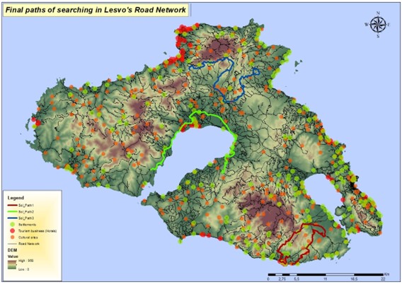
The mathematical analysis of a spatial network using graph theory and Geographical Information Systems (GIS) for path finding, has created the need to compare possible solutions to better solve spatial problems in road networks. The paper aims to provide a comprehensive and documented selection of the identification of similar routes on a spatial network through the development of a spatial Similarity Index. The index compares the geographical characteristics of routes (altitude, length, distance from points of interest) drawn in a spatial network and calculates the percentage of similarity between the routes and the criteria that contributed to their drawing. The purpose of this multicriteria indicator is to select the optimal solution for spatial problems that occur in a network, such as transport, energy, environment, sport, and tourism. This leads to the Similarity Index serving as a reliable tool in decision-making for local and regional development. The case study is the Greek island of Lesbos, with a complex road network that develops over a relief with strong differences in altitude. In addition, there are many points of tourist, cultural and economic interest on the island, which helps to find the path that largely fulfils all geographical parameters.
Research Highlights:
•Search algorithm to find paths in spatial networksusing GIS and graph theory.
•Network analysis to find similar paths with the same spatial characteristics.
•Decision making onlocal development using spatial networkanalysis.
Downloads


References
- Agourogiannis P., Lepeniotis C., Tataris G., Kavroudakis D., (2018). “Geographical Analysis of Road Networks for the Identification of Similar Routes The Case of Long Race Athletic Events.” In the 11th International Conference of the Hellenic Geographical Society, 1–7. Lavrion.
- Agourogiannis P., Batsaris M., (2019). “Web based Geographical Information System for cultural routes”, 2nd International Conference on Cul-tural Informatics, Communication & Media Studies 13-15 June, Mytilini.
- Agourogiannis, P., Kavroudakis, D., Batsaris, M., (2021). Spatial Analysis on Networks: Towards identifying similarity of routes. European Journal of Geography 12, 45–57. https://doi.org/10.48088/ejg.p.ago.12.4.045.057
- Ahmadzai, F., Rao, K.M.L., Ulfat, S., (2019). Assessment and modelling of urban road networks using Integrated Graph of Natural Road Network (a GIS-based approach). Journal of Urban Management 8, 109–125. https://doi.org/10.1016/j.jum.2018.11.001
- Ahmed, S., Ibrahim, R.F., Hefny, H.A., (2017). GIS-Based Network Analysis for the Roads Network of the Greater Cairo Area 10. Proceedings of the International Conference on Applied Research in Computer Science and Engineering ICAR'17, Lebanon. https://ceur-ws.org/Vol-2144/paper2.pdf
- Bartzokas-Tsiompras, A., (2022). Utilizing OpenStreetMap data to measure and compare pedestrian street lengths in 992 cities around the world. European Journal of Geography, 13(2), 127–141. https://doi.org/10.48088/ejg.a.bar.13.2.127.138
- Batsaris, M., Kavroudakis, D., Soulakellis, N. A., & Kontos, T., (2019). Location-Allocation Modeling for Emergency Evacuation Planning in a Smart City Context. International Journal of Applied Geospatial Research, 10(4), 28–43. https://doi.org/10.4018/ijagr.2019100103
- Batsaris, M., Kavroudakis, D., Hatjiparaskevas, E., Agouroiannis, P., (2021). Spatial Decision Support System for Efficient School Location-Allocation. European Journal of Geography 12, 31–44. https://doi.org/10.48088/ejg.m.bat.12.4.031.044
- Boeing, G. (2022). Street network models and indicators for every urban area in the world. Geographical Analysis, 54(3), 519-535.
- https://doi.org/10.1111/gean.12281
- Buchin, K., Buchin, M., van Kreveld, M., Luo, J., (2011). Finding long and similar parts of trajectories. Computational Geometry 44, 465–476.
- https://doi.org/10.1016/j.comgeo.2011.05.004
- Chen, Q., Xu, N., (2019). Research on the Shortest Path Analysis Method in Complex Traffic Environment Based on GIS, in: 2019 IEEE 4th Ad-vanced Information Technology, Electronic and Automation Control Conference (IAEAC). Presented at the 2019 IEEE 4th Advanced Infor-mation Technology, Electronic and Automation Control Conference (IAEAC), IEEE, Chengdu, China, pp. 208–212. https://doi.org/10.1109/IAEAC47372.2019.8997883
- CRAN. 2019. “The Comprehensive R Archive Network.”, (2019). https://cran.rproject.org
- Derekenaris, G., Garofalakis, J., Makris, C., Prentzas, J., Sioutas, S., Tsakalidis, A., (2001). Integrating GIS, GPS and GSM technologies for the effec-tive management of ambulances. Computers, Environment and Urban Systems 25, 267–278. https://doi.org/10.1016/S0198-9715(00)00025-9
- Dijkstra, E.W., (1959). A note on two problems in connexion with graphs. Numerische Mathematik, 1, 269–271. https://doi.org/10.1007/BF01386390
- Durduran, S.S., (2010). A decision making system to automatic recognize of traffic accidents on the basis of a GIS platform. Expert Systems with Applications 37, 7729–7736. https://doi.org/10.1016/j.eswa.2010.04.068
- Elsheikh, R.F.A., Elhag, A., Sideeg, S.E.K., Mohammed, A.E., Gism, N.A., Allah, M.S.A., (2016). Route Network Analysis in Khartoum City. SUST Journal of Engineering and Computer Science, 17(1), 50-57. https://repository.sustech.edu/bitstream/handle/123456789/16648/Route%20Network%20Analysis%20...%20.pdf?sequence=1&isAllowed=y
- Gaglione, F., Gargiulo, C., & Zucaro, F., (2022). Where can the elderly walk? A spatial multi-criteria method to increase urban pedestrian accessi-bility. Cities, 103724. https://doi.org/10.1016/j.cities.2022.103724
- Huang, B.-X., Chiou, S.-C., Li, W.-Y., (2020). Accessibility and Street Network Characteristics of Urban Public Facility Spaces: Equity Research on Parks in Fuzhou City Based on GIS and Space Syntax Model. Sustainability 12, 3618. https://doi.org/10.3390/su12093618
- Hwang, J.-R., Kang, H.-Y., Li, K.-J., (2006). Searching for Similar Trajectories on Road Networks Using Spatio-temporal Similarity, in: Manolopoulos, Y., Pokorný, J., Sellis, T.K. (Eds.), Advances in Databases and Information Systems, Lecture Notes in Computer Science. Springer Berlin Heidel-berg, Berlin, Heidelberg, pp. 282–295. https://doi.org/10.1007/11827252_22
- Inderwildi, O., King, S.D. (Eds.), (2012). Energy, Transport, & the Environment. Springer London, London. https://doi.org/10.1007/978-1-4471-2717-8
- Jaccard, P., (1901). Etude de la distribution florale dans une portion des Alpes et du Jura. Bulletin de la Societe Vaudoise des Sciences Naturelles 37, 547–579. https://doi.org/10.5169/seals-266450
- Johnston, J.W., (1976). Similarity indices I: what do they measure. (No. BNWL-2152(Add.1), 7256702). https://doi.org/10.2172/7256702
- Kavroudakis D., Agourogiannis P., Batsaris M. Vaitis M., Kavroudakis E., Kouloumentas P. (2019). Similarity of paths in spatial networks: The case of long-distance athletic events, 22nd AGILE Conference, June 2019, Limassol, Cyprus
- Lee, J.-G., Han, J., Whang, K.-Y., (2007). Trajectory Clustering: A Partition-and-Group Framework. SIGMOD’07, Beijing, China http://hanj.cs.illinois.edu/pdf/sigmod07_jglee.pdf
- López DN, Camus PA, Valdivia N, Estay SA., (2019). Integrating species and interactions into similarity metrics: a graph theory-based approach to understanding community similarity. PeerJ 7:e7013. https://doi.org/10.7717/peerj.7013
- Magdy, N., Sakr, M.A., El-Bahnasy, K., (2017). A generic trajectory similarity operator in moving object databases. Egyptian Informatics Journal 18, 29–37. https://doi.org/10.1016/j.eij.2016.07.001
- Margariti, M., (2022). Literary Geography: Applying Geocriticism in ‘The Mermaid Madonna’ by Stratis Myrivilis. European Journal of Geogra-phy 13 (5), 15-26. https://doi.org/10.48088/ejg.m.mar.13.5.15.26
- Mitsi, T.K., Argialas, D.P., Vamvoukis, K., (2020). Modification of a groundwater prospect zone index using remotely sensed data and the analytic network process in the eastern part of Lesvos island, Greece. European Journal of Geography 11 (4), 126-143. https://doi.org/10.48088/ejg.t.mit.11.4.126.143
- Okabe, A., Sugihara, K., (2012). Spatial analysis along networks: statistical and computational methods, Statistics in practice. Wiley, Chichester, West Sussex.
- Oluyinka Christopher, A., (2020). Comparative Analyses of Diversity and Similarity Indices of West Bank Forest and Block A Forest of the Interna-tional Institute of Tropical Agriculture (IITA) Ibadan, Oyo State, Nigeria. International Journal of Forestry Research, 1–8. https://doi.org/10.1155/2020/4865845
- Panahi, S., Delavar, M.R., (2008). A GIS-based Dynamic Shortest Path Determination in Emergency Vehicles. World Applied Sciences Journal, 3 (Supple 1), 88-94. https://www.idosi.org/wasj/wasj3(supplement%201)/14.pdf
- Paraskevopoulos, Y., Bardosa, A., Photis, Y.N., (2019). Exploring the impact of network configuration and transport accessibility on population dynamics. The case of Naxos island, Greece. European Journal of Geography 10(4), 177-194
- Rodrigue, J.-P., Comtois, C., Slack, B., (2013). The geography of transport systems, Third edition. ed. Routledge, London; New York.
- Sevtsuk, A., & Mekonnen, M. (2012). Urban network analysis. Revue internationale de géomatique 22(2), 287-305. https://doi.org/10.3166/rig.22.287-305
- Shafabakhsh, G.A., Famili, A., Bahadori, M.S., (2017). GIS-based spatial analysis of urban traffic accidents: Case study in Mashhad, Iran. Journal of Traffic and Transportation Engineering (English Edition) 4, 290–299. https://doi.org/10.1016/j.jtte.2017.05.005
- Shang, S., Chen, L., Wei, Z., Jensen, C.S., Zheng, K., Kalnis, P., (2017). Trajectory similarity join in spatial networks. Proceedings of the VLDB En-dowment 10(11), 1178–1189. https://doi.org/10.14778/3137628.3137630
- Srivastava, S., Shukla, R.P., (2016). Similarity and difference of species among various plant communities across grassland vegetation of north-eastern Uttar Pradesh. Tropical Plant Biology, 3(2), 364-369
- Sushma, M.B., Reddy, V., 2021. Finding an Optimal Path With Hospital Information System Using GIS-based Network Analysis. WSEAS TRANSAC-TIONS ON INFORMATION SCIENCE AND APPLICATIONS 18, 1–6. https://doi.org/10.37394/23209.2021.18.1
- Tiakas, E., Papadopoulos, A.N., Nanopoulos, A., Manolopoulos, Y., Stojanovic, D., Djordjevic-Kajan, S., (2009). Searching for similar trajectories in spatial networks. Journal of Systems and Software 82, 772–788. https://doi.org/10.1016/j.jss.2008.11.832
- Tobler, W.R., (1970). A Computer Movie Simulating Urban Growth in the Detroit Region. Economic Geography 46, 234. https://doi.org/10.2307/143141
- Vaitis M., Kavroudakis D., Koukourouvli N., Simos D. (2017). Spatiotemporal Analysis of road traffic accidents at Lesvos Island Greece, Smart, In-clusive and Resilient Small and Medium-sized Cities and Island Communities in the Mediterranean: Exploring Current Research Paths and Experience-based Evidence, Heraklion-Crete / Greece, September 28-29
- Zeng, W., Church, R.L., (2009). Finding shortest paths on real road networks: the case for A*. International Journal of Geographical Information Science 23, 531–543. https://doi.org/10.1080/13658810801949850