
How Do General Upper Secondary School Students Interpret Map Information? Geomedia Literacy and Visual Map Elements in Finland’s Geography Matriculation Examination
Published 2026-08-05
Keywords
- Geography education,
- Geomedia literacy,
- General upper secondary school students,
- Map elements,
- Map interpretation
- Matriculation examination ...More
How to Cite
Copyright (c) 2026 Anni Lehtoranta, Petteri Muukkonen, Terhi Mäntylä

This work is licensed under a Creative Commons Attribution 4.0 International License.
Accepted 2026-08-01
Published 2026-08-05
Abstract
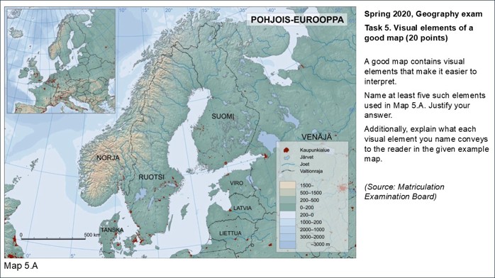
This study examines general upper secondary school students’ geomedia literacy in a high-stakes assessment context by analysing 272 essay answers to a map-related question in Finland’s nationwide geography Matriculation Examination (spring 2020). The task (“Visual elements of a good map”) asked students to identify at least five map elements and justify what each element conveys using a provided source map. Using qualitative content analysis combined with simple frequency counts, we coded (1) which visual elements were named and (2) how students justified their purpose, grouping justifications into four recurring categories: delivering information, helping interpretation, working tools for analysing information, and enhancing map quality. Most students treated map elements primarily as information deliverers and interpretation aids, while fewer described them as tools for measurement, comparison, or inference. Although many answers demonstrated basic competence in naming key elements (e.g., legend, scale bar, symbols, colours, coordinates), recurring misconceptions emerged, especially over-interpreting attributes not supported by the map (e.g., inferring population or vegetation zones) and misunderstanding scale bar use. The findings suggest that geography education should strengthen explicit and sustained teaching of critical map reading, including evidence-based justification, limits of inference, and deliberate practice with scale and symbology in both printed and digital maps.
Highlights:
- Students mostly treated map elements as information deliverers and interpretation aids
- Misconceptions often involve over-inference and misunderstanding the scale bar
- Findings support teaching critical geomedia literacy via evidence-based map reading
Downloads




References
- Anunti, H. (2023). Geomedia skills for 21st century geography learners: Educational experiments in teaching and learning with geomedia. University of Oulu. https://urn.fi/URN:ISBN:9789526238326
- Arthurs, L., Baumann, S., Rice, J., & Litton, S. D. (2023). The development of individuals’ map-reading skill: What research and theory tell us. International Journal of Cartography, 9(1), 3–28. https://doi.org/10.1080/23729333.2021.1950318
- Briwa, R., & Wetherholt, W. (2020). Teaching critical cartography in the introductory geography classroom. The Geography Teacher, 17(4), 162–168. https://doi.org/10.1080/19338341.2020.1828135
- Fast, K., & Abend, P. (2022). Introduction to geomedia histories. New Media & Society, 24(11), 2385–2395. https://doi.org/10.1177/14614448221122168
- Felgenhauer, T., & Quade, D. (2012). Society and geomedia: Some reflections from a social theory perspective. In T. Jekel, A. Car, J. Strobl, & G. Griesebner (Eds.), GI_Forum 2012: Geovisualization, society and learning (pp. 74–82). Herbert Wichmann Verlag & VDE Verlag GmbH.
- Finn, J., & Palis, J. (2015). Introduction: The medium, the message, and media geography in the 21st century. GeoJournal, 80, 781–790. https://doi.org/10.1007/s10708-015-9646-2
- Finnish National Agency for Education. (2014). National core curriculum for basic education 2014. Finnish National Agency for Education.
- Finnish National Agency for Education. (2015). National core curriculum for general upper secondary education 2015. Finnish National Agency for Education.
- Finnish National Agency for Education. (2019). National core curriculum for general upper secondary education 2019. Finnish National Agency for Education.
- Fisher, F. (2014). Everyday geomedia use and the appropriation of space. In T. Jekel, E. Sanchez, I. Gryl, C. Juneau-Simon, & J. Lyon (Eds.), Learning and teaching with geomedia (pp. 10–28). Cambridge Scholars Publishing.
- Gryl, I., & Jekel, T. (2018). Spatially informed citizenship education as an approach for global understanding. In A. Demirci, R. de Miguel González, & S. Bednarz (Eds.), Geography education for global understanding: International perspectives on geographical education (pp. 43–56). Springer. https://doi.org/10.1007/978-3-319-77216-5_4
- Hilander, M. (2017). Kuvatulkinta ja maantieteellinen tarkkaavaisuus: Semioottinen ajattelutapa nuorten visuaalisen lukutaidon osana [The interpretation of photographs and geographical vigilance: A semiotic way of thinking as part of young people’s visual literacy skills] [Doctoral dissertation, University of Helsinki] (Helsinki Studies in Education, No. 5). University of Helsinki. http://hdl.handle.net/10138/179235
- Hynynen, L., Nylén, T., Hirvensalo, V., Lammi, P., & Muukkonen, P. (2022). Maantieteen opettajien näkemyksiä geomediasta ja geomediaopetuksesta [Geography teachers’ views on geomedia and geomedia education]. Terra, 134(4), 241–252. https://doi.org/10.30677/terra.120326
- Hynynen, L., Jylhä, M., Lammi, P., Nylén, T., & Muukkonen, P. (2023). Geomediakyvykkyys, geomedialukutaito ja niiden kehittyminen [Geomedia competence, geomedia literacy, and their development]. Terra, 135(2), 92–98. https://terra.journal.fi/article/view/129399/80099
- Jekel, T., Sanchez, E., Gryl, I., Juneau-Simon, C., & Lyon, J. (Eds.). (2014). Learning and teaching with geomedia. Cambridge Scholars Publishing.
- Jokisuu, P. (2022). Verkkopohjaisten karttojen saavutettavuushaasteet [Accessibility challenges of web-based maps] [Master’s thesis, University of Jyväskylä]. University of Jyväskylä. https://jyx.jyu.fi/handle/123456789/82900
- Krokfors, L. (2017). Opetussuunnitelman pedagogiset mahdollisuudet – opettajat uuden edessä [Pedagogical possibilities of the curriculum – teachers facing something new]. In T. Autio, L. Hakala, & T. Kujala (Eds.), Opetussuunnitelmatutkimus: Keskustelunavauksia suomalaiseen kouluun ja opettajankoulutukseen [Curriculum research: Opening perspectives for the Finnish school system and teacher education] (pp. 247–266). Tampere University Press.
- Lammi, P., Hirvensalo, V. J., Nylen, T., Hynynen, L. S., Pellikka, A., & Muukkonen, P. (2026a). GeoTAITO: A Framework for students’ geomedia skills and proficiency levels. European Journal of Geography, 17(1), 260–266. https://doi.org/10.48088/ejg.p.lam.17.1.260.266
- Lammi, P., Hirvensalo, V., Nylén, T., Hynynen, L., Pellikka, A., & Muukkonen, P. (2026b). GeoTAITO-malli: Nuorten geomediataidot ja osaamisen tasot [The GeoTAITO model: Young people’s geomedia skills and proficiency levels]. Ainedidaktiikka, 10(2), 81–112. https://doi.org/10.23988/800ejp61
- Lapenta, F. (2011). Geomedia: On location-based media, the changing status of collective image production and the emergence of social navigation systems. Visual Studies, 26(1), 14–24. https://doi.org/10.1080/1472586X.2011.548485
- Lehtoranta, A. (2024). Opiskelijoiden geomedian lukutaidon ilmeneminen maantieteen ylioppilaskokeessa [How students’ geomedia literacy manifests in the geography Matriculation Examination] [Master’s thesis, University of Jyväskylä]. https://urn.fi/URN:NBN:fi:jyu-202406034206
- Leivo, J., Ruth, O., & Muukkonen, P. (2020). Ajattelun taidon tasot maantieteen ylioppilaskokeessa taloudellisen kestävän kehityksen koekysymyksissä ja vastauksissa [Levels of thinking skills in the geography Matriculation Examination: Test questions and answers on economic sustainable development]. Ainedidaktiikka, 4(3), 64–101. https://doi.org/10.23988/ad.92201
- Matriculation Examination Board. (2020). Maantieteen koe 17.3.2020: Lopulliset hyvän vastauksen piirteet [Geography examination 17 March 2020: Final characteristics of a good answer]. https://info.ylioppilastutkinto.fi/hvp/final/2020_k_ge.pdf
- Matriculation Examination Board. (2024). Structure of the examination. https://www.ylioppilastutkinto.fi/en/matriculation-examination/structure-examination
- Matriculation Examination Board. (2026). Tilastot [Statistics]. https://www.ylioppilastutkinto.fi/fi/tietopalvelut/tilastot
- Monmonier, M. (2019). How to lie with maps (3rd ed.). University of Chicago Press.
- Moorman, L. A., & Crichton, S. (2018). Learner requirements and geospatial literacy challenges for making meaning with Google Earth. International Journal of Geospatial and Environmental Research, 5(3), Article 5.
- Muukkonen, P. (2018). Maantieteen opettajien opetuskäytännöt kielellisesti moninaisessa luokassa [Geography teachers’ teaching practices in a linguistically diverse classroom]. In R. Rinne, N. Haltia, S. Lempinen, & T. Kaunisto (Eds.), Eriarvoistuva maailma – tasa-arvoistava koulu? [An unequalising world – an equality-promoting school?] (pp. 297–328). Finnish Educational Research Association. http://hdl.handle.net/10138/287681
- Muukkonen, P. (2023). Kriittiselle geomedian lukutaidolle on suuri tarve [There is a great need for critical geomedia literacy]. Terra, 135(4), 177–178. https://doi.org/10.30677/terra.142022
- Muukkonen, P. (2026). Kriittinen geomedialukutaito – mistä ihmeestä on kyse? [Critical geomedia literacy – what on earth is it about?]. Natura, 65(1), 20–23.
- Muukkonen, P., Nylén, T., & Hirvensalo, V. (2021). Hyvän kartan elementit [Elements of a good map]. In P. Muukkonen, T. Nylén, V. Hirvensalo, A. Luoma, & M. Söderholm (Eds.), Paikkatiedon ja geomedian keskeisiä käsitteitä: Oppimateriaalia maantieteen opetukseen perusopetuksessa ja lukiossa. Library of Open Educational Resources. https://urn.fi/urn:nbn:fi:oerfi-202209_00024934_2
- Muukkonen, P., Hynynen, L., Jäntti, L., & Lammi, P. (2022). Geomedia on keskeinen osa maantieteen opetusta, mutta miksi ja mitä se on? [Geomedia is a central part of geography education, but why and what is it?]. Terra, 134(3), 191–193. https://terra.journal.fi/article/view/121685/73054
- Ooms, K., De Maeyer, P., Dupont, L., Van der Veken, N., Van de Weghe, N., & Verplaetse, S. (2016). Education in cartography: What is the status of young people’s map-reading skills? Cartography and Geographic Information Science, 43(2), 134–153. https://doi.org/10.1080/15230406.2015.1021713
- Pellikka, A., Nylén, T., Hirvensalo, V. J., Hynynen, L., Lutovac, S., & Muukkonen, P. (2024). Understanding teachers’ perceptions of geomedia: Concerns about students’ critical literacy. Teaching and Teacher Education, 144, Article 104607. https://doi.org/10.1016/j.tate.2024.104607
- Puertas Aguilar, M., Conway, B., de Lázaro-Torres, M., de Miguel González, R., Donert, K., Lindner-Fally, M., Parkinson, A., Prodan , D., Wilson, S., & Zwartjes, L. (2022). A teaching model to raise awareness of sustainability using geoinformation. Espacio Tiempo y Forma. Serie VI, Geografía, 15, 23–42. https://doi.org/10.5944/etfvi.15.2022.33687
- Riihelä, J., & Mäki, S. (2015). Designing and implementing an online GIS tool for schools: The Finnish case of the PaikkaOppi project. Journal of Geography, 114(1), 15–25. https://doi.org/10.1080/00221341.2014.897362
- Statistics Finland. (2025, May 28). Students in general upper secondary education numbered 112,800 in 2024. https://stat.fi/en/publication/cm10ln3pq8tpl07w1lgtprrfn
- Strobl, J. (2014). Technological foundations for the GISociety. In T. Jekel, E. Sanchez, I. Gryl, C. Juneau-Simon, & J. Lyon (Eds.), Learning and teaching with geomedia (pp. 2–9). Cambridge Scholars Publishing.
- Szigeti-Pap, C., Kis, D., & Albert, G. (2023). Understanding map misinterpretation: Factors influencing correct map reading and common errors. ISPRS International Journal of Geo-Information, 12(12), Article 479. https://doi.org/10.3390/ijgi12120479
- Vogler, R., & Henning, S. (2014). Using geomedia for collaborative learning environments: The example of participatory spatial planning. In T. Jekel, E. Sanchez, I. Gryl, C. Juneau-Simon, & J. Lyon (Eds.), Learning and teaching with geomedia (pp. 187–199). Cambridge Scholars Publishing.
- Wang, E. S. T., & Lin, R. L. (2017). Perceived quality factors of location-based apps on trust, perceived privacy risk, and continuous usage intention. Behaviour & Information Technology, 36(1), 2–10. https://doi.org/10.1080/0144929X.2016.1143033
- Wisniewski, P., Safi, M. I., Patil, S., & Page, X. (2020). Predicting smartphone location-sharing decisions through self-reflection on past privacy behavior. Journal of Cybersecurity, 6(1), Article tyaa014. https://doi.org/10.1093/cybsec/tyaa014
- Zwartjes, L., de Lázaro, M. L., Donert, K., Sánchez, I. B., de Miguel González, R., & Wołoszyńska-Wiśniewska, E. (2017). Literature review on spatial thinking. GI Learner Project. https://www.gilearner.ugent.be/wp-content/uploads/GI-Learner-SpatialThinkingReview-3.pdf