
Published 2026-08-03
Keywords
- Critical geomedia literacy,
- Curriculum interpretation,
- Geography education,
- Geomedia,
- Geomedia skills
- Geomedia skill framework ...More
How to Cite
Copyright (c) 2026 Panu Lammi, Virpi Hirvensalo, Tua Nylén, Laura Hynynen, Anne Pellikka, Petteri Muukkonen

This work is licensed under a Creative Commons Attribution 4.0 International License.
Accepted 2026-08-01
Published 2026-08-03
Abstract
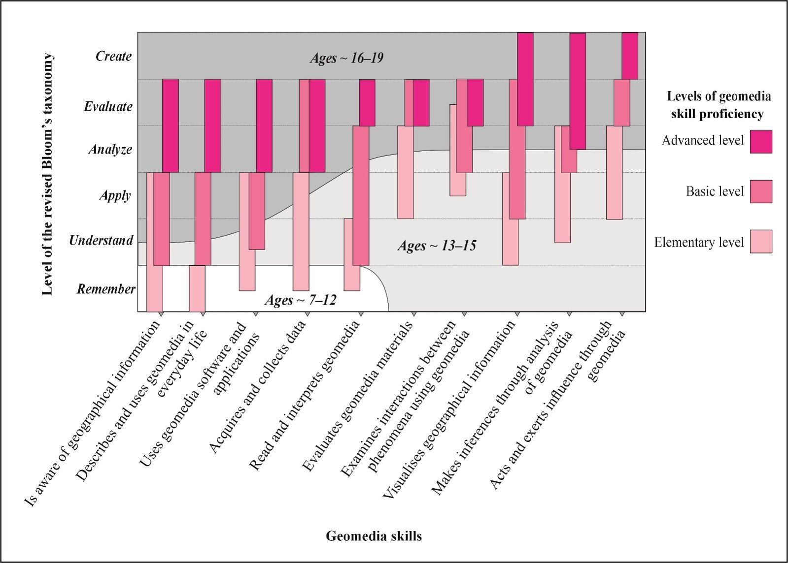
Young people encounter geographically framed information through maps, GIS, geospatial data, images, statistics, and location-based services while navigating misinformation. GeoTAITO (Geo + Finnish taito, ‘skill’ or ‘know-how’) is a conceptual framework that structures ten geomedia skill areas and three proficiency levels across primary, lower secondary, and upper secondary education. It focuses on geomedia skills as one dimension of broader geomedia competence, alongside critical geomedia literacy. Based on conceptual synthesis and teacher-informed empirical refinement, the model supports curriculum interpretation, instructional planning, and assessment while highlighting students’ higher-order analytical and critical geomedia skills.
Highlights:
- GeoTAITO model clarifies what geomedia skills mean at different school levels
- GeoTAITO specifies 10 geomedia skill areas and three proficiency levels
- The model includes analysis, evaluation, and participation as core higher-order geomedia skills
______________________________________________________
Secondary Publication Statement: This Short Communication is a secondary publication of a model originally reported in Finnish. It is presented in accordance with recognised international guidance on secondary and translated publication (including the ICMJE Recommendations on Overlapping Publications; COPE guidance on translations), to make the model accessible to an international readership that does not read Finnish. The primary publication is: Lammi, P., Hirvensalo, V., Nylén, T., Hynynen, L., Pellikka, A., & Muukkonen, P. (2026). GeoTAITO-malli: Nuorten geomediataidot ja osaamisen tasot. Ainedidaktiikka, 10(2), 81–112. https://doi.org/10.23988/800ejp61. This communication faithfully reflects the data and interpretations of the primary publication and reports no new primary data.
______________________________________________________
Downloads




References
- Anderson, L. W., & Krathwohl, D. R. (Eds.). (2001). A taxonomy for learning, teaching, and assessing: A revision of Bloom’s taxonomy of educational objectives. Longman.
- Ash, J., Kitchin, R., & Leszczynski, A. (2018). Digital turn, digital geographies? Progress in Human Geography, 42(1), 25–43. https://doi.org/10.1177/0309132516664800
- Fast, K., Jansson, A., Tesfahuney, M., Bengtsson, L. R., & Lindell, J. (2017). Introduction to geomedia studies. In K. Fast, A. Jansson, J. Lindell, L. R. Bengtsson, & M. Tesfahuney (Eds.), Geomedia studies: Spaces and mobilities in mediatized worlds (pp. 1–17). Routledge.
- Finnish National Agency for Education. (2014). National core curriculum for basic education 2014 (Regulations and guidelines 2014:96). Finnish National Agency for Education.
- Finnish National Agency for Education. (2019). National core curriculum for general upper secondary education 2019 (Regulations and guidelines 2019:2a). Finnish National Agency for Education.
- Finnish National Agency for Education. (2020). Assessment criteria for basic education (31 December 2020) (Regulation OPH-4042-2020).
- Finnish National Agency for Education. (2023). Environmental studies: Assessment of learning and competence in grades 3–6 (Amendment regulation OPH-172-2023).
- Hilander, M. (2017). Kuvatulkinta ja maantieteellinen tarkkaavaisuus: Semioottinen ajattelutapa nuorten visuaalisen lukutaidon osana [The interpretation of photographs and geographical vigilance: A semiotic way of thinking as part of young people’s visual literacy skills] [Doctoral dissertation, University of Helsinki]. Kasvatustieteellisiä tutkimuksia, 5.
- Hilander, M. (2024). Visuaaliset aineistot lukion maantieteen oppikirjoissa [Visual materials in upper secondary geography textbooks]. In A. Kaasinen, E. Haataja, A. Laherto, & I. Södervik (Eds.), Ainedidaktisia näkökulmia perustaitojen opetukseen ja arviointiin [Subject-didactic perspectives on teaching and assessing basic skills] (pp. 149–170). Ainedidaktisia tutkimuksia: Suomen ainedidaktisen tutkimusseuran julkaisuja 28. Suomen ainedidaktinen tutkimusseura ry. https://doi.org/10.23988/sats.1098
- Hynynen, L., Nylén, T., Hirvensalo, V., Lammi, P., & Muukkonen, P. (2022). Maantieteen opettajien näkemyksiä geomediasta ja geomediaopetuksesta [Geography teachers’ views on geomedia and geomedia education]. Terra, 134(4), 241–252. https://doi.org/10.30677/terra.120326
- Hynynen, L., Jylhä, M., Lammi, P., Nylén, T., & Muukkonen, P. (2023). Geomediakyvykkyys, geomedialukutaito ja niiden kehittyminen [Geomedia capability, geomedia literacy, and their development]. Terra, 135(2), 92–98. https://terra.journal.fi/article/view/129399/80099
- Jekel, T., Sanchez, E., Gryl, I., Juneau-Sion, C., & Lyon, J. (2014). Learning and teaching with geomedia. Cambridge Scholars.
- Lammi, P., Hirvensalo, V., Nylén, T., Hynynen, L., Pellikka, A., & Muukkonen, P. (2026). GeoTAITO-malli: Nuorten geomediataidot ja osaamisen tasot [The GeoTAITO model: Young people’s geomedia skills and proficiency levels]. Ainedidaktiikka, 10(2), 81–112. https://doi.org/10.23988/800ejp61
- Lapenta, F. (2011). Geomedia: on location-based media, the changing status of collective image production and the emergence of social navigation systems. Visual Studies, 26(1), 14–24. https://doi.org/10.1080/1472586X.2011.548485
- Muukkonen, P. (2026). Kriittinen geomedialukutaito – mistä ihmeestä on kyse? [Critical geomedia literacy – what on earth is it about?]. Natura, 65(1), 20–23.
- Muukkonen, P., Hynynen, L., Jäntti, L., & Lammi, P. (2022). Geomedia on keskeinen osa maantieteen opetusta, mutta miksi ja mitä se on? [Geomedia is a central part of geography education, but why and what is it?]. Terra, 134(3), 191–193. https://terra.journal.fi/article/view/121685/73054
- National Research Council. (2006). Learning to think spatially. The National Academies Press. https://doi.org/10.17226/11019
- Pellikka, A., Nylén, T., Hirvensalo, V., Hynynen, L., Lutovac, S., & Muukkonen, P. (2024). Understanding teachers’ perceptions of geomedia: Concerns about students’ critical literacy. Teaching and Teacher Education, 144, Article 104607. https://doi.org/10.1016/j.tate.2024.104607
- Puttick, S. (2020). Digital technologies and their roles in knowledge recontextualization and curriculum making. In N. Walshe & G. Healy (Eds.), Geography education in the digital world: Linking theory and practice (pp. 33–45). Routledge.
- Vogler, R., & Hennig, S. (2013). Providing geomedia skills beyond (post)secondary education. In T. Jekel, A. Car, J. Strobl, & G. Griesebner (Eds.), GI_Forum 2013 – Creating the GISociety (pp. 317–327). Austrian Academy of Sciences Press. https://doi.org/10.1553/giscience2013
- Zwartjes, L., de Lázaro, M. L., Donert, K., Sánchez, I. B., De Miquel González, R., & Wołoszyńska-Wiśniewska, E. (2017). Literature review on spatial thinking. GI Learner Project. https://www.gilearner.ugent.be/wp-content/uploads/GI-Learner-SpatialThinkingReview-3.pdf